
Historical Timeline of Denham Springs
Pre 18th Century

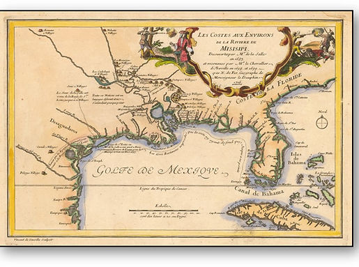
“The Houma Indians were apparently the inhabitants of what is now Livingston Parish at the time the first explorations by Europeans occurred. It is generally conceded that the Houma hunting grounds extended north of the famed "red stick" in Baton Rouge, which divided their lands from that of the neighboring tribe, and that they ranged far to the east, including Livingston Parish as part of their territory. Whether the Tunica Indians, who massacred inhabitants of several Houma villages and drove the remainder of the tribe away from the area, extended their conquest beyond the Amite River is not a matter of available record.” ...Clark Forrest

Links for Further Research
French Exploration Period


Pierre Le Moyne d'Iberville
1661-1706

Jean-Baptiste Le Moyne de Bienville
1680-1767

Model of a French Ship from the fleet of
Pierre Le Moyne d’Iberville at
Pointe-a’-Calliere Museum in Montreal
Links for Further Research
The Lone Star Republic of West Florida


That section of Louisiana east of the Mississippi river, south of the Mississippi state line, north of lake Pontchartrain and Maurepas, extending to the Pearl River, which includes the parishes of West Feliciana, East Feliciana, East Baton Rouge, St. Helena, Livingston, Tangipahoa, Washington, and St. Tammany — a territory once called the “County of Feliciana,” is known today by many as the “Florida Parishes.”
It was the westernmost section of a land that was known for nearly half a century (1763-1810) as “West Florida” and over it flags of two European kingdoms flew, the Union Jack of England for 16 years, and the banner of Spain for 31 years. On the soil of this fruitful southern land was enacted one of the most spectacular events in Louisiana’s colorful history. For the space of 74 days, this part of the present state was a free and independent nation, with its own governing officials, its own army, its own navy, its own flag, its own declaration of independence. To secure this daring, if short-lived freedom, liberty-loving Anglo-Saxon inhabitants, many British to the backbone, literally fashioned their plowshares into swords and, at the point of these weapons, captured a fort by force and beat down the defenders, to throw off the shackles of a hated European despotism. ...Read More
...Arthur, Stanley Clisby. The Story of the West Florida Rebellion. St. Francisville: St. Franciville Democrat, 1935. Print.
Denham Springs 1800's
1828-
-
The original land claims of John Noblet and Alexander Hogue form what is now the older section of Denham Springs, including the first residential and business districts. In 1828, Hougue was a Scot who migrated from Georgia.
-
William Denham, a Wilkinson County, Mississippi, native, married Mercy Hogue, the daughter of Alexander Hogue; three months later he purchased the 640 acres (2.6 km2) originally claimed by his father-in-law. Denham purchased the land and a slave for $1,350 - a sum equal to $31,150 in 2019.
-
William Denham was born in 1805 in Wilkinson County. He was the son of Hugh and Margaret Denham. They had 12 children including Sarah Denham who later married Robert Benton.
-
William and Mercy had 8 children when they lived in the area. The 1860 Census lists 2 more children in East Baton Rouge Parish.
-
After 1880 William and Mercy and their 3 youngest children moved to Texas.
-
1832-
-
Livingston Parish was originally part of the Florida Parishes. The parish was created on February 10, 1832, when the state legislature split St. Helena Parish in two.
-
Historians differ as to which one, but the parish was definitely named after either Robert or Edward Livingston.
1850-
-
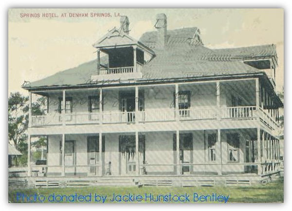
It was in the 1850s that the area we know as Denham Springs was called Amite Springs.
1855-
-
On May 1, 1855, Denham sold the Hogue tract to Stamaty Covas of New Orleans for $3,050, and Denham eventually moved to Baton Rouge and to Texas.
-
Apparently during the time Covas owned the Hogue-Denham tract, and before the Civil War, a health resort did flourish at Amite Springs—as the hamlet was known at the time. Several newspaper articles and advertisements survive from that period, which describe the hotel and the facilities which it offered.
-
Following the Civil War, Covas, lost possession of the Hogue-Denham tract when George L. Minton bought it for delinquent taxes of $124.00.

The Times-Picayune, Pg. 4, Aug. 7, 1856

The Times- Picayune (New Orleans, La.)
Wednesday, July 18, 1860 Page 1
1856-
-
An article in the Baton Rouge Daily Comet, on June 25, 1856, notes that a bridge of boats had been formed at Benton's Ferry over the Amite River to facilitate travel to Amite Springs.

Benton's Ferry
-
Benton's Ferry was the name of the post office which was established near Amite Springs on January 25, 1856, and named for Robert Benton, its first postmaster and also the operator of the ferry across the Amite.
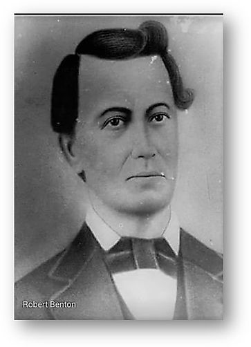
Robert Benton was graduate of Yale University and an early settler in Denham Springs.

Sarah Denham Benton was married to Robert Benton. She was the sister of William Denham for whom Denham Springs was named.
About Robert Benton
-
Robert was the son of John and Hannah Benton from East Feliciana’
-
When he came to Denham Springs he was a widower with 3 children.
-
He married Sarah Denham and owned and operated a large plantation with a cotton gin, sawmill, commissary and warehouse.
-
He floated his lumber and cotton bales to Mr. Vincent’s port to be floated to New Orleans or to be transported by one of the steamers in the area.
-
He had served in the Mexican War and was called Colonel Benton.
-
He had studied law at Yale University and was an accomplished violinist.
-
Colonel Benton lost three sons in the Civil War which began in 1861.
-
He was captured during a skirmish at Benton Ferry and held as prisoner at the old New Orleans Mint until the end of the war in 1865.
-
During this time the Yankees burned down the plantation and all the out lying buildings, except the small overseers house, because Colonel Benton refused to divulge any information about the Livingston Parish home guard.
-
After the Civil War the Colonel was elected judge and lived until about 1870.


1869-
-
In 1869, the parish lost territory when Tangipahoa Parish was created.
-
It later gained additional land when Maurepas Island was made part of the parish.
1881-
-
Survey map of Livingston Parish, Louisiana. Shows some landowners' names. This is a certified copy of Grandjean's original 1881 map, created by Reiner Swart in 1887. Acreages in red ink. Port Vincent and Galvestown [Galvez] shaded in red
From the Louisiana Digital Library
http://louisianadigitallibrary.org/islandora/object/lsu-sc-p16313coll57%3A56
